![]()
Back to 1995 Reports
1995 Annual Research and Extension Report
Vegetation
Sampling in Water Monitoring Sites at Buck Island Ranch OBJECTIVES
ACCOMPLISHMENT
J. Jeffrey Mullahey, George Tanner, and Ken Portier
Department of Wildlife Ecology and Conservation and Department of
Statistics
2.To determine the dry matter yield and nutrient loading from each
vegetation site.
3.To relate the nutrient loading data with the water quality data collected
from each site.
4. To develop a GIS database for modeling vegetation dynamics.
BACKGROUND
Five long-term water monitoring sites at the Buck Island Ranch were
implemented to collect and analyze surface water. Two sites are the east
and west marsh systems. Current management includes grazing (1 cow/3 acres)
in the winter months with no inputs (ie. fertilizer). Vegetation sampling
is needed to determine the composition of plants in each marsh system and
document changes in species composition over time, to determine the acreage
associated with the different vegetation zones, and loading from the
vegetation in each marsh system.
METHODOLOGY
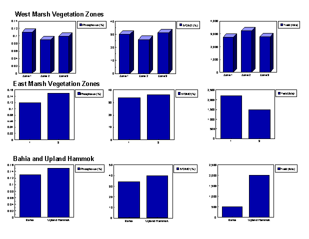
Each vegetation site will be sampled in the spring after cattle are removed to improved pasture. Within the west marsh, three areas (replications) were identified. Each area consisted of a sawgrass zone, transition zone, and upland hardwood hammock. Within each zone, three 10 m long permanent transects were established for a total of 27 transects. Five 0.25 m2 quadrants were located on each transect at 1,3,5,7 and 9 m. Percent composition by plant species was ocularly estimated in each quadrant. In addition, a total biomass harvest was collected from one transect per vegetation zone with each replication. From the harvested material, dry matter yield (lb/a) will be calculated and nutrient analyses (N, P, IVOMD) conducted. Frequency of occurrence will be calculated for each species in a vegetation zone. In the east marsh, two areas (sawgrass zone, upland zone) were selected for a total of 18 transects. In the bahiagrass area there will be 3 transects and a total of 5 transects in the upland hammock. Biomass yield and nutrient analyses will also be determined.
FUTURE PLANS
Vegetation sampling for year 2 is currently being conducted. The vegetation data will be added to a GIS database to enhance existing vegetation maps and to determine the size (acres) of each vegetation zone in the two marsh systems. Finally, based on the total area of each vegetation zone, nutrient loadings for an entire system can be determined and related to water quality data.
The senior author can be reached at:
Dr. J.J. Mullahey
Tel: (941) 657-5221
Fax: (941) 657-5224
E-mail: jjm@gnv.ifas.ufl.edu
2001 Southern DataStream